Sunday, April 30, 2017

Explore the Okavango Delta.


Named by Lonely Planet as one of the 'Hot Destinations for 2016', Botswana's star is definitely on the rise. So what makes it so special? Well for start, it's hard to go past beautiful landscapes and the quality and abundance of wildlife. Then there's its rare combination of desert and delta. The Kalahari Desert makes up more than 80% of this landlocked country, and the vast sponge into which the swollen Okavango River disappears each year creates the largest inland delta in the world – the Okavango Delta.

Gazetted as UNESCO's thousandth World Heritage Site in 2014, the Okavango Delta, with its vast and diverse wildlife species, is one of Africa's premier safari destinations, providing a truly unique wilderness experience. Forming part of the Kalahari Basin, situated at the southern periphery of the Great Rift Valley, it covers a staggering 22,000 square kilometres. And while the periphery is semi-arid, the Delta itself is a patchwork of cool clear streams, lagoons, floodplains and forested islands. The result is one of the world's most diverse wildlife habitats, home to over 200,000 large mammals, 400 bird species and 70 species of fish, most spectacularly on display in the dry winter season as vast numbers of wildlife flock to where the floodwaters infiltrate the surrounding plains.

At the heart of the Okavango Delta lies the world-renowned Moremi Game Reserve, providing a peaceful haven where animals have been protected for decades. Known as the 'predator capital of Africa', the Moremi is famed for its big cat and bird populations, and also for large herds of elephant and buffalo, giraffe and other plains game – and occasionally Africa's rare wild dogs, that roam the savannah.

But no visit to the Okavango Delta is complete without a mokoro ride. One of the most iconic symbols of the Delta, the mokoro was originally the only form of transport for fishing or transporting people and goods around its channels. Still used by the 'river bushmen' or BaYei people, these canoe-like vessels offer up a unique way to explore the Delta's waterways.

For much of each year the Okavango Delta is a labyrinth of lagoons and streams where hippos fight for bathing rights and crocodiles wait for unwary antelope to linger too long over a drink. Poling through the byways created by the floodwaters is an unforgettable, serene experience that allows passengers to get breathtakingly close to big game and to see the world from a totally different angle. It's a chance to sit back and relax as you glide through lily ponds, seeing eye-to-eye with a buffalo as it laps water from the river, watching crocodiles sunbathe on the banks or cruising past a pod of hippos as they lie in a pool.

Specialist safari operates three unique luxury boutique properties in exclusive private concessions in the Okavango Delta – Sanctuary Baines Camp, Sanctuary Stanley's Camp and flagship property, Sanctuary Chief's Camp. All three offer mokoro rides seasonally based on the water levels of the Delta.


Tuesday, April 25, 2017

Take a trek through British Columbia’s wilderness with Google Maps and BC Journeys


British Columbia Canada is getting put on the map, literally. Through a partnership with Google, stunning imagery from British Columbia’s wild places has been added to Google Maps, complemented with interviews with BC locals, imagery, drone footage, immersive 360° video, and featured businesses on the new BC Journeys platform www.bcexplorer.com/journeys.

Using Google Street View, people from around the globe can now virtually hike in some of the province’s vast wilderness and be inspired by the powerful nature they see around them. 

British Columbia joins a select group of bucket-list Google Street View Trekker destinations such as the Pyramids of Giza, the Grand Canyon and the Galapagos Islands.

There are currently 176 new British Columbia Google Street View Treks now featured on Google Maps, with 14 more to be uploaded by Google. Here is a sample of the Treks:

Sunshine Coast Trail
Kettle Valley Trail (Myra Canyon)
Blackcomb Mountain (Decker Loop)
Lake Magog (Assiniboine Lodge)
108 Lake Accessible Trail
Anthony Island, Gwaii Haanas
Bridge Glacier
Pacific Rim (Schooner Cove Trail)
Windfall Lake (near Tumbler Ridge)

Find treks in British Columbia by reviewing the BC Explorer platform http://www.bcexplorer.com/journeys or through Google Maps, by searching for BC’s Google Street View Treks.

Quotes:

Marsha Walden, CEO, Destination BC
“There are over one billion monthly users of Google Maps. Through these Treks and our new interactive platform, BC Journeys, we can give people a window into our wilderness like never before – creating a connection before people even leave their homes. Combining this powerful, immersive video footage with compelling, authentic stories creates an augmented reality experience that is a pretty potent recipe for driving visitation.”

Nicole Bell, Google Street View Trekker Expert
“We’re incredibly proud to partner with Destination British Columbia in this Trekker project. We’ve worked together for years to bring the world to British Columbia and bring British Columbia to the world. These new Street View images, especially some of the more remote locations in BC, are an important part of Google’s goal to create the world’s most comprehensive, accurate and usable map. More than one billion people around the world use Google Maps every month, and we are thrilled to share some of British Columbia's iconic landscapes.”

Here’s how you can see BC’s Street View Treks:
  • Search for a place in Google Maps. Drag the yellow ‘Pegman’ to a place on the map.
  • The blue areas on the map show where Google has collected ‘Street View’ content.
  • To move around, hover your cursor in the direction you want to go. Your cursor becomes an arrow that shows which direction you're moving. To see where you might go next, look for the “X”; click once to travel to the “X”. To look around, click and drag your mouse. You can also use the arrows to the left and right of the compass. 

Sunday, April 9, 2017

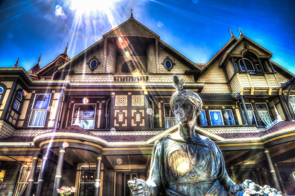
Winchester Mystery House - a strange obsession


Located in the beautiful Santa Clara Valley in San Jose on Winchester Blvd. and I-280 near the intersection of I-880, this beautiful but bizarre 160-room Victorian mansion was built by Sarah L. Winchester, widow of the famed Winchester rifle manufacturer’s son. 

Last 30 Days' Most Popular Posts