


A number of significant and stunningly beautiful outback landforms have been named after William Finke. But just who was this enigmatic German and what was his connection to early South Australian exploration? Colin Judkins delves into some dusty drawers.
Born in Germany around 1814, he arrived in South Australia aboard the vessel “Tom O’Shanter” in 1836 (part of that state's so-called first fleet). The only name that resembled his on the ships' books was Johann Wilhelm Finke, so it appears he anglicised his name on arrival.
He was quite wealthy for the time and had an air of social standing about him but in the formative stages of the state and Adelaide, he had to chip in (get his hands dirty so to speak) to get things done. He was a very capable bloke, in time becoming a successful prospector, pastoralist, land and business owner. However, if that was just his lot in life, today his name would be forgotten, the reason he is remembered is that he was a generous sponsor of John McDouall Stuart's many explorations.
I’m not belittling his importance, for without people like him chipping in with their own money many explorations would not have been able to get off the ground or be carried out, most Governments didn’t have the funds for them to go ahead.
The first landform that had his name applied to it was Mt Finke (about 150 km north of Ceduna in S.A.). In August 1858 McDouall Stuart was the first European to feast his eyes on the surrounding country from its summit. He wrote in his journal at the time, “Nothing meets the eye save a dense scrub as black and dismal as midnight, a fearful country”. He came across it whilst returning from the first of his six major expeditions. Finke himself would have never seen that view and so wasn’t annoyed that something so “apparently bleak” had his name put to it, if he was, it was rectified later on.
 |
| Giles's cairn on the summit of Mt Finke (Colin Judkins) |
Indulge me here as I tell you a bit more about Mt Finke; The second person to climb it was Ernest Giles whilst he was on his 1875 attempt to make a crossing from Beltana/Port Augusta S.A. to Perth.
By using camels on that expedition, he was able to follow a number of water holes (some which he discovered) until he finally reached the Western Australian border. (The Trans Australian Railway Line followed those waterholes when it was built, being completed in 1917). He then risked a 312-mile (502 km) dry stage across the Great Victoria Desert to reach the remote Queen Victoria Springs, (one helluva good job of navigating there!!) He was then able to complete his journey to Perth in fairly easy stages via known water holes and small gold mining communities.
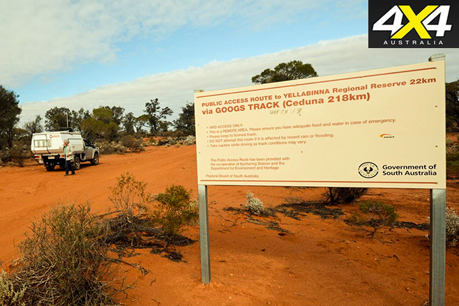
Back to Mt Finke, when Giles climbed it he built a rock cairn on the summit, which is still there to this day. For the next 100 years, very few people would have climbed it (and that access was only from the north), but that was about to change, all because of one man, the one and only John “Goog” Denton.
John was raised on a farm near Denial Bay S.A. As a boy, one of his jobs was to collect the farm's eggs and sell them to locals to supplement the family income. His mum nicknamed him “Goog” short for 'Googy Eggs' and for the rest of his life, everyone knew him as Goog.
In 1965 Goog married his sweetheart, Jenny, and after marrying they moved to a property just north of Ceduna, which they called “Lone Oak”.
The property was originally 5800 acres of scrub just north of the dog fence with thick bush and sandhills extending north to the Transcontinental (Trans) Australian railway line. (That property which is now part of the Yumbarra Conservation Park and the Yellabinna Wilderness Protection Area, had Mt Finke on it)
They never really knew what was on their land so out of curiosity and the thought, “what’s out there?” another thing intrigued Goog if he built a road/track into or through it, what else could it be used for.
He concluded that a road/track from Ceduna to meet the east-west railway line at Tarcoola would allow better access for him and locals to sell their produce to wider markets with the aide of the railway. So he set about building one, he received no government support or financial assistance, he did, however, receive a lot of moral and financial support in the form of fuel and equipment from property owners in the area who could see the potential and benefit of such a road.
 |
| Goog's Track (Alan Whiting/Whichcar) |
Eventually in 1976 after three long years, the battle against the sandhills (all 363 of them!) and scrub was won, Goog’s dream had been realised the rail line was reached. Not only did the completed track have potential as mentioned above, but it also opened up access to some stunning country that previously was unheard of or if ever visited. It also allowed for easier access to Mt Finke.
I drove the approximately 130 km long 4WD-only “Googs Track” a few years back, to add my name to the illustrious list of those who have climbed Mt Finke's lofty peak, 369 metres above sea level (roughly 260 metres above the surrounding plain) so maybe not so lofty after all.
Back to the origins of landforms with the name Finke (we now know who did it and why).
It was on one of Stuart's next expeditions in early April 1860, that he came across the southern extremities of a dry river bed. As he followed it, it became more pronounced and worthy of having a name put to it. That river is now known as the Finke River. Hopefully, in time it will be better known (or equally) by what the locals knew and know it as: “Larapinta”.
 |
| Glen Helen Gorge, one of the few permanent waterholes on the Finke River (Colin Judkins) |
The Finke runs for around 600 km, ending roughly near the western edge of the Simpson Desert. Usually just a handful of waterholes, it can, however, become a raging torrent during rare flood events. On those extreme occasions, water can flow into the Macumba River and then into Lake Eyre, a total distance from its headwaters of around 750 km.
The Finke River has long been referred to as "the oldest river in the world” once draining Australia’s ancient inland seas. In places such as the James Range (around Hermannsburg N.T.), the Finke has cut a deeply meandering course, this only occurs on flat plains, that means the river must have been in existence before the ranges were pushed up. That event happened between 300 and 400 million years ago (around the Devonian period). Amazingly in parts, its course is believed to date back 340 million years, well before the time of dinosaurs.
It is known for certain it has followed the exact same route for the past 15 to 20 million years and generally flowed along with the same one for around 100 million years. If I was Finke, it would have made me pretty proud to have my name bestowed upon it.
Another place that carried his name was a railway siding on the Central Australia Railway (the original Ghan line). The siding created in 1925 was called Finke (due to its close proximity to the river). It began as a small workingmen's camp, where the fettlers (railway workers) lived. Aboriginal people started visiting the siding as soon as it was built establishing a camp in the sandhills nearby, trading dingo scalps, wildflowers, artefacts and other items for water and food.
 |
| A lovely and educational way to brighten up the facilities at Finke (Colin Judkins) |
In time a small community grew around it, for many years it was known by the name of Finke. (The line was relocated 150 kms to the west in 1981) The community is still there today but now calls their tiny settlement by its traditional name: Aputula.
Other places and even events carry William Finke’s name, due to their connection to the river, such as the Finke Gorge National Park and the Finke Desert Race.


